
 Earlier this month, I posted about a backpack outing we did in June to Lake Mary from Brighton. It was on that trip that I wanted to see how to get into this area from the Alta side, up Little Cottonwood Canyon. …and so we experienced it this weekend!
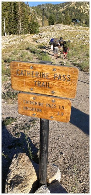
Our Troop left from the Catherine Pass Trailhead in the Albion Basin on Friday evening around 6pm. About an hour or so later, we arrived at the edge of Lake Catherine. We set up camp near the lake and had a CAMPFIRE! Oh, have I ever missed that!! Scout outings haven’t quite been the same this year with the restrictions that have prevented us from having one all summer long. So it was great to finally sit around a fire with friends telling stories, laughing and talking about whatever came to mind.
The next morning we cooked breakfast, explored adjacent trails, scoped out possible camp spots for another time, took pictures, skipped rocks in the lake and filled our water bottles for the easy hike down.
September is my most favorite time of the year for backpacking in Utah. The days are warm but not scorching. The nights are cold but not freezing. The bugs are minimal, if any, and fall is starting to show in a vibrant display of colors. After a long hot summer, I look forward to this change of season that leads to the onset of winter!
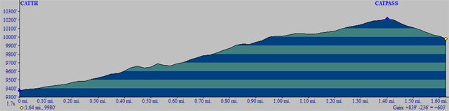
 Here’s a Google Earth file that has been updated since our last trip to these lakes. This hike is very similar to the route coming in from Brighton as far as distance and elevation goes. Below is an evelation profile from the Catherine Pass Trailhead to Lake Catherine:
After visiting this area from a different perspective, I got to thinking about other ways you could increase the adventure level of this scout outing on the Wasatch Front:
- Hike to Sunset Peak for an awesome 360° view
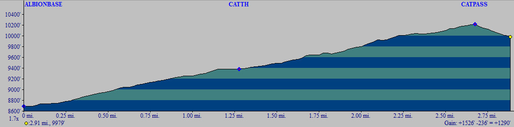
- Start from Alta’s “Albion Base” parking lot and take the Albion Meadows Trail to double the distance and elevation gain to Lake Catherine
- Before you head home, leave your packs in the car and do the short hike to Cecret Lake on the opposite side of Albion Basin
- Refill your water bottles at Cecret Lake and head up to Sugarloaf Peak* for a view of Mineral Basin and the backside of Snowbird
* Sugarloaf Peak is the 13th tallest peak in SLC at 11,051’
