
Part of our Varsity Scout High Adventure experience this summer was to complete a 50 mile bike ride around Bear Lake. Convenient as it is, the road circling Bear Lake is exactly 50 miles! So on Day 1, after a nice hearty breakfast, we started our cycling adventure at 8am from the LDS church parking lot in St. Charles, ID. We chose to do this loop in a clockwise manner from the northwest corner so that we hit the “hardest” part first.
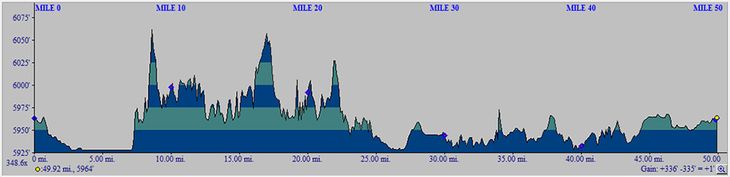
The flattest section of this route around Bear Lake was our first 5 miles along the North Beach road, which provided an excellent warm-up. The next 15 mile section was the only “hard” part from a terrain perspective… meaning, not long after you round the corner and began heading south along the Eastshore road to the Idaho/Utah border, there are some rolling hills that could get some leg muscles burning. After that, the remaining 30 miles are just comfortable cruising.
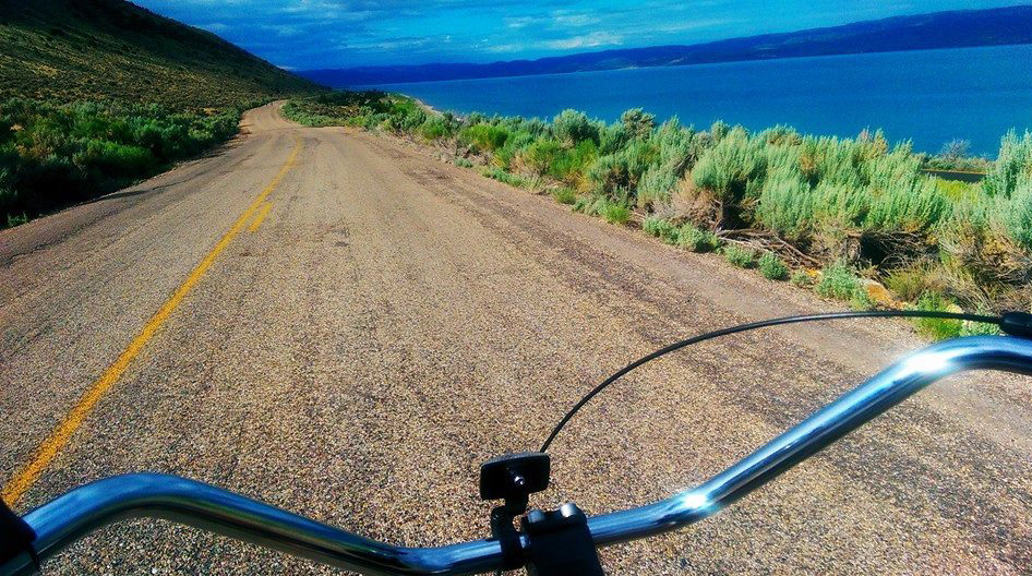
My 17 year old son and I did this 50-miler on beach bikes. Mine was a 3-speed Electra Cruiser while his was a single speed Huffy Cranbrook that he bought at a yard sale for $40. We definitely did not look like your typical “cyclist” on a long road ride…and we didn’t care! We had a grand time talking, laughing and eating snacks from his handlebar basket. I only wish I was able to take more pictures. About four hours later, we were back at the starting point feeling great!
If you’re planning on doing this, here are a few logistics you may want to consider:
- An adult leader in our group was willing to drive a support vehicle along the route to pick up any boys having trouble. Some in our group had mechanical problems with their bikes (shoulda had it tuned up before a trip like this boyz!), others had physical problems with their bodies (not enough pre-conditioning rides to be ready) and only one got up close and personal with the pavement (suffering only minor scrapes and minimal road rash).
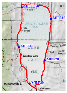
- The support vehicle took our fallen riders and had them manage refueling stations at the 20 and 30 mile marks. Almost everyone took a break at the 20-mile station for water, snacks and to give their legs a rest after the rolling hills section. At 30 miles, not many needed to stop again since most had found their rhythm by then and were already beyond the half-way point (mentally).
- I wish there was an designated bike trail all the way around this popular lake, because the southwest section along Hwy 30 from Laketown to Sweetwater was a bit sketchy regarding road safety. We didn’t have any close calls, but we also did this ride on a Thursday morning to help minimize any risk from busier weekend traffic along the west side.
- As you prepare for this grand bike ride, make sure you arrange a few 10, 15 and 25 mile training rides at home to help condition your legs and seat. You can/should use these shorter rides as building blocks for completing the Cycling merit badge. In fact, *everyone* should be lined up to earn the Cycling merit badge upon completing this 50-miler around Bear Lake (otherwise, you’re just doing inadvertent bike rides).
 For those unfamiliar with Bear Lake and the road we’re talking about here, see the attached Google Earth file . The elevation profile below also clearly shows the section of rollers I mentioned earlier.
Hope this helps with your planning and preparations. It’s a really fun bike ride!

We don’t like to ride on the road where cars are going past. Where are the specific bikcycle riding or walking paths which are paved around Bear Lake?
Thanks for the informaiton…I am ‘Scouting’ this out for my son, who has had some feet issues from birth, and hoping a 50 miler is not too tough for his situation. I notice your elevation shows this going from 5900 ft to 6900 feet. Is that really correct? On the BSA’s page the elevation change looked like it bounced around from 5900 to 6050 feet, https://www.trappertrails.org/files/5818/Bike-The-Bear-Route-Map-
But I have not been there to see it yet, and don’t know. Just wanted to ask if the elevation change of 1000 feet is accurate for this ride?
No, the elevation change is only about 130 feet. I fixed my elevation profile… sorry for the confusion.